
Story
Does Google Maps Work in China in 2026? 3 Photo Spots That Do
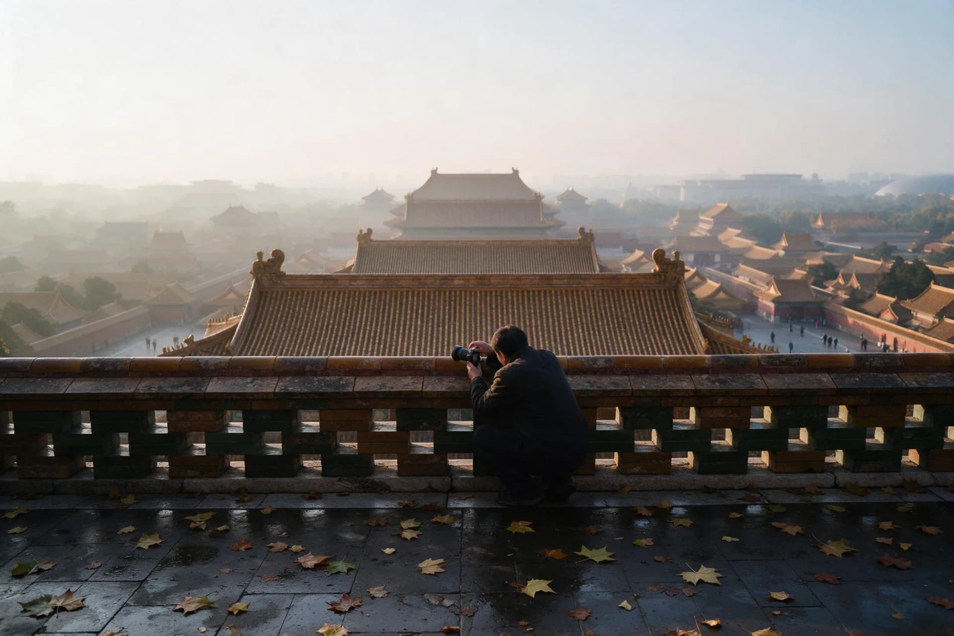
Google Maps is not a dependable field companion in mainland China, but the fix is simpler than a VPN: install Amap, save Chinese gate names and carry an offline backup. This photo-led guide shows how to reach three cinematic viewpoints in Beijing, Shanghai and Guilin, with exact ticket prices, October 25 light windows, crowd cutoffs and camera or phone settings.
No: Google Maps is not reliably usable in mainland China as of October 21, 2026. A pre-downloaded offline area may display, but live search, routing and traffic usually fail; use free Amap for navigation. Do not bet a CNY 60 Xianggong Hill sunrise on a VPN; carry screenshots and a backup.
The real map problem on a photo trip is not signal alone. It is the handoff from an English place name to a specific Chinese gate before dawn, when staff are scarce and the wrong drop-off can cost 20 minutes of usable light. Fix that handoff in advance. Two weeks before departure, install Amap and Google Maps, download the relevant Google map areas, and save both the Chinese name and pin for each entrance. Then test in airplane mode for five minutes; if the name, route and nearest metro exit disappear, your backup has failed.
Amap is the primary field tool because its local business data and live traffic match mainland roads. Google Maps remains useful for pre-trip research and hotel-area orientation, not as proof that a walking route is open. A personal VPN is also not a planning foundation: only approved channels are legal, availability changes, and hotel Wi-Fi may block the connection. An offshore-routed roaming plan can sometimes open Google services without a VPN, but confirm that routing with your carrier before purchase. For photographers, the dependable setup is simpler: Amap plus three screenshots showing each Chinese gate name, a map pin and a nearby landmark.
1. Beijing: Wanchun Pavilion, Jingshan Park. Exact viewpoint: the south balustrade on the summit terrace, facing south over the Forbidden City. Entry is CNY 2 and can be reserved by passport through the park's same-day mini-program. On October 25, 2026, sunrise is about 06:35; arrive by 06:05, because the eastern edge fills first and tour groups reach the summit after 07:30. The best frame is 06:25–06:55, when roofs retain detail before haze flattens. Camera: 35–70mm, f/8, 1/125 sec, ISO 200. Phone: use the main 1x lens, tap the bright sky, pull exposure down about one stop and leave HDR off. Use the Amap pin “景山公园南门” for the south gate, not the general park name.
2. Shanghai: the Bund promenade. Exact viewpoint: the granite river railing between Nanjing East Road and Jiujiang Road, facing east across the Huangpu toward Lujiazui. There is no ticket. Sunrise on October 25 is about 06:06; work from 05:30 to 07:00 while the promenade is quiet. The same railing is shoulder to shoulder from 18:30 to 22:00, so dawn is the cleaner choice. Camera: 24–50mm, f/5.6, 1/125 sec, ISO 200, metering for the sky and letting the towers fall into silhouette. Phone: 1x lens, tap the sky, exposure down 0.7–1.0 and no digital zoom. Pin “外滩南京东路” in Amap, then walk east; cars cannot stop on the main Bund road.
3. Guilin: Xianggong Hill. Exact viewpoint: the upper viewing platform's north railing, looking down on the 180-degree Li River bend near Xingping. The ticket is about CNY 60. Sunrise on October 25 is about 06:42, with soft color until roughly 07:45; reach the platform by 05:40 because minibuses begin arriving at 05:00 and the rail is full by 06:10. Camera: 24–70mm, f/8, 1/125 sec, ISO 200 and a polarizer turned only enough to cut water glare. Phone: 1x lens, night mode off, tap-focus on the river bend and exposure down one stop. Save “相公山” and the ticket-gate pin separately, since the hill name alone may route you below the climb.
Build weather and access decisions into the same alarm. Check visibility rather than a sun icon: for Jingshan and Xianggong Hill, distant ridges vanishing into grey mean the wide shot will fail even if the forecast says clear. For the Bund, rain can be useful because the promenade reflects the skyline, but wind and umbrella traffic make a tripod unsafe. Keep one flexible morning per city. If the first dawn is washed out, use it to confirm the gate, security check and exact rail, then return on the backup morning instead of moving to an untested viewpoint under time pressure.
Your next step is a six-item phone checklist: install Amap, save the Chinese gate name, screenshot the pin, download an offline map, record sunrise and crowd cutoff, and copy the settings above before you leave the hotel. Add your passport for Jingshan and CNY 60 for Xianggong Hill. For the full network and app setup, read our Google Maps and VPN guide; for more frames after sunrise, use the linked Beijing, Shanghai and Li River photography guides. The photograph improves when the navigation is boring and the light is the only surprise.
Good to know
- Google Maps status, October 21, 2026
- Live search, routing and traffic are unreliable on mainland networks; a previously downloaded offline area may display. Amap is free and should be the primary field app.
- Two-week setup
- Install Amap and Google Maps 14 days before departure; save 3 entrance screenshots per city and test each one in airplane mode for 5 minutes. Carry a Chinese hotel address as backup.
- Tickets and viewpoints
- Jingshan south balustrade CNY 2; Bund railing between Nanjing East Road and Jiujiang Road free; Xianggong Hill upper north railing about CNY 60. Passport details may be required at booking.
- Light windows, October 25, 2026
- Beijing sunrise about 06:35, arrive 06:05; Shanghai about 06:06, shoot 05:30–07:00; Guilin about 06:42, climb by 05:40 and shoot until about 07:45. All times are China Standard Time.
- Crowd cutoffs
- Jingshan tour groups arrive after 07:30; the Bund peak runs 18:30–22:00; Xianggong Hill vans start at 05:00 and its upper rail is full by 06:10. Build one backup morning into every city.
- Starting settings
- Camera: 24–70mm, f/8, 1/125 sec, ISO 200, adjusting shutter speed first. Phone: main 1x lens, tap the brightest important area, exposure down 0.7–1.0, HDR or night mode off unless the frame is static.
Frequently asked questions
Does Google Maps work in China if I download an offline map?
It may display the saved area, but live search, current traffic, new places and reliable routing usually do not work on mainland networks. Download the map before departure and also save the destination's Chinese name and pin in Amap for the actual trip.
Do I need a VPN to use Google Maps in China in 2026?
Do not build your photo schedule around one. Personal VPN connections are not a dependable legal workaround, and only approved channels are sanctioned. Amap is free and designed for mainland navigation; an international roaming plan may also route data offshore, but verify that with your carrier.
Which navigation app should photographers use in China?
Use Amap as the primary app because it has accurate mainland roads, public transit and live traffic. Keep a screenshot of the exact gate and Chinese place name as backup, and pin the nearest metro exit for an early-morning walk rather than relying on a single signal.
What are the best sunrise times for these three photo spots?
On October 25, 2026, sunrise is about 06:35 in Beijing, 06:06 in Shanghai and 06:42 in Guilin. Arrive 30–60 minutes early for Jingshan or Xianggong Hill, since rail space fills before the best color; the Bund is easiest 30 minutes before sunrise.
Which of these China photo spots need a ticket?
Jingshan Park costs CNY 2 and Xianggong Hill costs about CNY 60; the Bund promenade is free. Bring your passport for Jingshan's reservation, and treat the Xianggong Hill ticket as cash-ready backup even if you booked through an agent.